
 KOR
KOR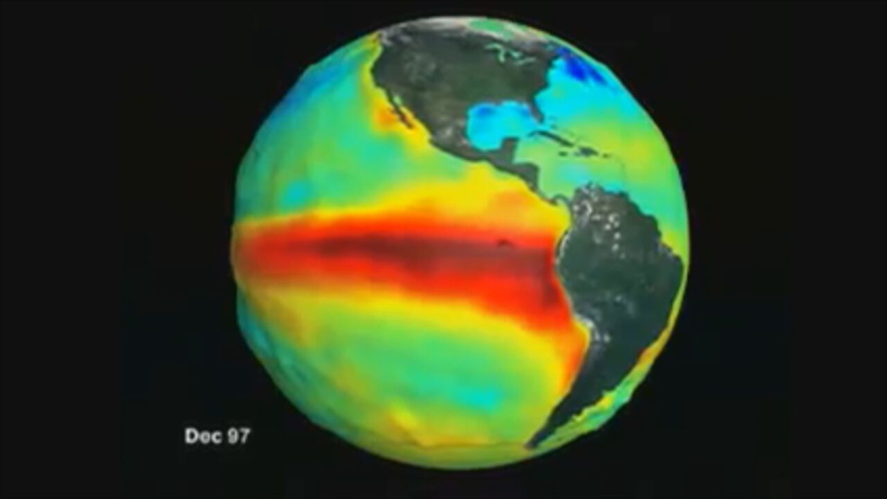
⚡ Key Takeaways
The World Meteorological Organization (WMO) announced that the already formed El Niño is expected to develop into a very strong event by the end of this year, with a near 100% probability of persisting through February 2027.
Driven by unusually high ocean temperatures across the tropical Pacific and the impact of El Niño, risks of drought, flooding, wildfires, food insecurity, and supply chain disruptions are rising in Asia, Latin America, and Africa.
A recent preprint study suggests that climate change has made extreme El Niño events of this magnitude approximately six times more likely compared to pre-industrial levels, though the study has not yet undergone peer review.
1. "Could Be the Strongest on Record": WMO Warns of Mega El Niño
On September 3 local time, the World Meteorological Organization (WMO) released an outlook warning that the current El Niño will intensify further in the coming months. An analysis by the WMO Global Long-Range Forecast Production Centers showed a near 100% probability that El Niño conditions will continue through February 2027. This marks the first time the WMO has issued an El Niño/La Niña forecast with such a high degree of certainty.
El Niño is a naturally occurring climate phenomenon characterized by higher-than-average sea surface temperatures in the central and eastern equatorial Pacific, leading to shifts in atmospheric circulation patterns. When trade winds weaken, warm surface waters accumulated in the western Pacific shift eastward toward the central and eastern Pacific, while the upwelling of cold, deep waters along the coast of South America is suppressed. This shift influences precipitation, temperatures, and atmospheric circulation far beyond the tropical Pacific.
This year's El Niño is intensifying at an unusually rapid pace. According to the WMO, sea surface temperatures in the Niño 3.4 region—a key indicator for monitoring El Niño—averaged 1.5°C above normal from May to July this year. The temperature anomaly widened to 2.0°C in July, and weekly figures from late July through mid-August ran approximately 2.2°C to 2.6°C above average. Heat beneath the ocean surface is even more pronounced: in July and early August, subsurface temperatures in parts of the basin were observed at more than 8°C above average.
"If this trajectory continues, it could be stronger than any El Niño we have experienced since records began," WMO Secretary-General Celeste Saulo said at a press conference in Geneva. "It could literally be off the charts."
To date, this El Niño is classified among the top four strongest events observed since 1950. The WMO projects that El Niño will peak at a very strong level late this year, with climate impacts continuing well into 2027. UN Secretary-General António Guterres warned, "El Niño is supersizing before our eyes," adding, "Our planet has entered uncharted waters, and those waters are growing ever hotter."
However, a powerful El Niño does not mean all countries and regions will suffer the same form or intensity of impacts. The WMO emphasized that because regional climates are also influenced by other factors—such as sea surface temperatures in the Indian and Atlantic Oceans—regional outlooks issued by national meteorological services must be closely monitored.
2. From Wildfires to Canal Restrictions: Mounting Economic and Supply Chain Risks
El Niño is a naturally occurring climate pattern and is not directly caused by climate change. However, when a strong El Niño unfolds over an already overheated planet and ocean, the risks of extreme weather events such as heat waves, droughts, and torrential downpours are further magnified.
High temperatures, droughts, and precipitation shifts consistent with El Niño's impacts are already appearing across multiple regions. Still, individual wildfires, typhoons, or floods cannot be attributed solely to El Niño.
In Indonesia, wildfire damage is surging rapidly amid dry conditions. According to the Indonesian Ministry of Environment and Forestry, the area affected by wildfires reached approximately 202,000 hectares from January to July this year. The burnt area nearly doubled in the single month of July from the roughly 107,000 hectares recorded from January through June. While many fires are believed to have been deliberately set by individuals or corporations to clear land, dry conditions fueled by El Niño have made containment and suppression far more difficult.
In India, precipitation in August was 16% below the long-term average. The India Meteorological Department forecast that September rainfall would also fall below normal. Concerns are also emerging that total monsoon rainfall from June through September could end up approximately 15% below average. Continued rainfall deficits could affect not only summer-sown crops such as cotton, soybeans, corn, and pulses, but also the planting of winter crops like wheat and rapeseed.
In Peru, rising coastal water temperatures caused anchovies—a key export commodity—to migrate deeper and increased the proportion of juveniles, leading to suspended fishing operations and reduced catches. Because anchovies are a primary raw material for fishmeal and fish oil, lower Peruvian catches could ripple through global feed and aquaculture costs.
In China, more than 1 million people were evacuated in August due to Typhoon Dolphin. However, because typhoon genesis and tracks are driven by a complex mix of meteorological factors, it is difficult to attribute this specific typhoon directly to El Niño.
The Panama Canal, a vital artery of global maritime logistics, has also instituted transit restrictions. The Panama Canal Authority reduced daily vessel transits from 36 to 34 starting September 4, with plans for a further reduction to 32 starting September 15. This represents an overall reduction of approximately 11%. Rainfall in the Panama Canal watershed between May and August was 34% below normal, and water inflow into the basin dropped by 44%. The authority expressed concern that a prolonged and severe El Niño could pose long-term strain on canal water levels and the surrounding region's drinking water supply.
3. 49 Million More at Risk of Food Insecurity, Warning Lights for Marine Ecosystems
The UN World Food Programme (WFP) warned that this El Niño could exacerbate food crises in the world's most vulnerable regions. According to initial WFP analyses, at least 49 million additional people could face acute food insecurity by the end of 2027 due to El Niño's fallout. This does not mean 50 million people have newly fallen into severe hunger today; rather, it projects that the number of people unable to reliably access food could rise by that amount due to future harvest losses caused by droughts, floods, and heat waves.
The analysis focused on 45 countries already experiencing food insecurity and expected to be heavily affected by El Niño. The population facing acute food insecurity in these countries could rise by around 22%, from roughly 225 million to approximately 274 million. Central America and Southern Africa are expected to suffer the heaviest damage, with significant impacts also feared across East Africa, South Asia, and Southeast Asia. In the Asia-Pacific region, an estimated 8.2 million additional people could fall into acute food insecurity.
The WMO projects that above-normal temperatures are likely across almost all land areas from September to November 2026. In line with classic El Niño patterns, the likelihood of drier-than-normal conditions is elevated in Southeast Asia, Central America, and northern South America, while above-average rainfall is likely across parts of East Africa, southern South America, and portions of the southern United States. However, this represents a broad seasonal outlook rather than a definitive forecast of localized droughts or floods for specific cities or nations.
Concerns over marine heat waves are also mounting in waters around Australia. The Australian Bureau of Meteorology reported that in late August, ocean temperatures east and south of Tasmania were 2°C to 3°C above normal. Intensifying marine heat waves elevate risks across marine ecosystems and fisheries, including mass fish die-offs, coral bleaching, harmful algal blooms, and reduced catch volumes. However, there is currently no confirmed evidence linking the spread of avian influenza identified in Australia directly to marine heat waves or El Niño.
4. Extreme El Niño Amplified by Climate Change: Turning Forecasts into Early Action
El Niño typically occurs on a cycle of two to seven years and lasts roughly 9 to 12 months. It generally begins developing between March and June, reaching its peak intensity between November and February of the following year.
According to the Australian Bureau of Meteorology, the relative Niño 3.4 index stood 2.45°C above normal as of August 30, 2026—well above the bureau's 0.8°C threshold for El Niño. All predictive models project that tropical Pacific waters will warm further, potentially reaching the highest levels recorded since reliable observations began in 1950.
In a recently published preprint, researchers at the University of Melbourne analyzed that the probability of an extreme El Niño event of this scale occurring under present-day climate conditions is approximately six times higher than in the pre-industrial era. The researchers compared pre-industrial and modern climate conditions using multiple climate models. However, because this study is a preprint that has not yet undergone peer review, it should not be interpreted as meaning that climate change made this El Niño six times stronger, or that the occurrence of El Niño in general has become six times more likely. More precisely, it indicates that the probability of an El Niño of such extreme intensity emerging has increased roughly sixfold.
The WMO is working with national meteorological agencies to bolster early warning and disaster preparedness systems. The WFP has also initiated anticipatory action against floods and droughts in countries including South Sudan, Chad, Mauritania, Uganda, Guatemala, and El Salvador. Based on historical data, the WFP explained that investing $1 in anticipatory action before a disaster strikes can save between $3 and $7 in subsequent damages and humanitarian relief costs.
On August 19, the U.S. government announced plans to deploy the hospital ship USNS Comfort to the northern Pacific coast of Peru in February 2027. The United States and Peru are establishing a cooperative framework—including equipment, expert personnel, and reconnaissance flights—to mitigate El Niño damage and ensure swift response should disasters occur.
The impacts of El Niño can persist even after ocean temperatures subside from their peak. As accumulated ocean heat is released into the atmosphere, it can temporarily push global average temperatures higher in the year following El Niño's development. The 2023–2024 El Niño similarly contributed to making 2024 the hottest year on record.
A WMO official noted that considering the temporary warming effect following this El Niño, 2027 could potentially become the hottest year on record. However, this is presented as a possibility based on the current intensity of El Niño rather than a formal, quantitative annual temperature forecast. Secretary-General Saulo stressed, "An unprecedented El Niño demands unprecedented preparedness and response," adding, "We have no time to lose."
South Korea must also monitor not only the direct impact of El Niño on domestic weather, but also global price fluctuations for agricultural goods, fisheries products, and feed ingredients, as well as potential disruptions along specific maritime shipping routes. Still, it cannot be assumed that Panama Canal restrictions will directly drive up overall South Korean logistics costs. For South Korea, worsening crop yields in India and Southeast Asia, declining Peruvian fishmeal production, and international grain and raw material price volatility are more likely to pose direct burdens than the canal restrictions themselves.
Deep Dive Q&A
Q1. Why is this El Niño considered particularly dangerous compared to past events?
A1. Both its pace of development and the magnitude of sea surface and subsurface temperature increases are extraordinary. The weekly sea surface temperature anomaly in the Niño 3.4 region has already risen 2.2°C to 2.6°C above average, and subsurface temperatures in parts of the ocean have exceeded normal levels by more than 8°C. Forecast models indicate this El Niño could reach its strongest level since 1950 by late this year. Furthermore, higher baseline temperatures in the atmosphere and oceans caused by long-term global warming also heighten the risk of damage from extreme weather.
However, a powerful El Niño does not mean severe disasters will occur identically in every region. The nature and intensity of impacts depend on the season, geography, and other climate drivers such as sea surface temperatures in the Indian and Atlantic Oceans.
Q2. How could Panama Canal restrictions and agricultural/fishery disruptions impact the South Korean economy?
A2. Restrictions on Panama Canal transits could increase transit times and shipping costs for certain grain, energy, and container cargo traveling between the U.S. East Coast/Gulf Coast and Asia. However, because not all cargo bound for South Korea utilizes the Panama Canal, the impact on domestic logistics costs will vary depending on the item, point of origin, and availability of alternative routes.
A more direct impact on the South Korean economy could stem from rising grain, sugar, and edible oil prices caused by poor crop yields in India and Southeast Asia, as well as rising fishmeal and animal feed costs resulting from declining Peruvian anchovy catches. If such price increases persist over an extended period, they could translate into upward pressure on consumer prices for processed foods, livestock products, and dining out.
※ Please note: This article was translated by AI and may contain errors.




 Video News

 Video News
 Video News