SBS NEWS
Six North Korean Nuclear Tests Woke Sleeping Fault Line: Study Warns of Magnitude 6.3+ Earthquakes
Published : Sep 18, 2026 3:01 AM
A research study has been published revealing that North Korea's six nuclear tests conducted in Punggye-ri, Kilju County, North Hamgyong Province, between 2006 and 2017 activated massive fault lines in the area.
Pusan National University announced today (September 18) that, through a joint analysis of seismographs in South Korea and near Mount Paektu conducted with institutions including the China Earthquake Administration and the Chinese Academy of Sciences, it has identified seismic activity and the reactivation patterns of existing faults around Mount Mantap in Punggye-ri, North Korea.
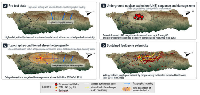
The research team confirmed that a fault of at least 20 kilometers has been reactivated in the Punggye-ri region, warning that a very large earthquake of magnitude 6.3 or higher could occur.
Based on investigations into historical records and other documents, the research team verified that no earthquakes perceptible to humans have occurred in the region since 23 BC.
Faults that had been dormant for thousands of years were awakened by North Korea's nuclear tests, triggering seismic activity.
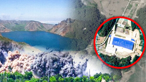 Video
Video
A precise observation of earthquakes in the region from January 2018 to May 2025 following North Korea's sixth and final nuclear test showed that a total of 1,339 natural earthquakes occurred, including micro-earthquakes of magnitude 2.0 or lower.
Among them, there were a total of 90 earthquakes of magnitude 2.0 or higher, and a large earthquake of magnitude 3.3 occurred on July 3, 2023.
Natural earthquakes continue to occur in the Punggye-ri area up to recent times.
Mount Mantap in Punggye-ri, where North Korea conducted its nuclear tests, features an asymmetrical structure where gentle and steep slopes are intermixed, making it an area with a complex stress structure—the forces exerted on underground rock masses.
The research team explained that as the six nuclear tests were carried out, the stress structure in the region was redistributed due to the impact.
The artificial earthquake from the sixth and final nuclear test was confirmed to be a magnitude 6.3 based on the U.S. Geological Survey, and satellite imagery captured the surrounding environment of Mount Mantap being devastated by the explosion's impact.
In addition, evidence was found showing that the peak of the mountain sank by 0.5 meters and shifted horizontally by 3.5 meters due to the blast impact.
There is also research indicating that fault reactivation could trigger earthquakes of magnitude 6.2 to 6.3 in the area, which could potentially affect the magma chamber of Mount Paektu located about 120 kilometers to the north.
The research findings by the joint team from Pusan National University and China have been published in the international academic journal Science in the United States.
Further details of this research will be reported today (September 18) on SBS 8 News.
Pusan National University announced today (September 18) that, through a joint analysis of seismographs in South Korea and near Mount Paektu conducted with institutions including the China Earthquake Administration and the Chinese Academy of Sciences, it has identified seismic activity and the reactivation patterns of existing faults around Mount Mantap in Punggye-ri, North Korea.
▲ The yellow solid line in Figure D indicates the fault zone discovered by the research team
The research team confirmed that a fault of at least 20 kilometers has been reactivated in the Punggye-ri region, warning that a very large earthquake of magnitude 6.3 or higher could occur.
Based on investigations into historical records and other documents, the research team verified that no earthquakes perceptible to humans have occurred in the region since 23 BC.
Faults that had been dormant for thousands of years were awakened by North Korea's nuclear tests, triggering seismic activity.
 Video
Video▲ Distribution of earthquakes over time in the Punggye-ri area (Video)
A precise observation of earthquakes in the region from January 2018 to May 2025 following North Korea's sixth and final nuclear test showed that a total of 1,339 natural earthquakes occurred, including micro-earthquakes of magnitude 2.0 or lower.
Among them, there were a total of 90 earthquakes of magnitude 2.0 or higher, and a large earthquake of magnitude 3.3 occurred on July 3, 2023.
Natural earthquakes continue to occur in the Punggye-ri area up to recent times.
Mount Mantap in Punggye-ri, where North Korea conducted its nuclear tests, features an asymmetrical structure where gentle and steep slopes are intermixed, making it an area with a complex stress structure—the forces exerted on underground rock masses.
The research team explained that as the six nuclear tests were carried out, the stress structure in the region was redistributed due to the impact.
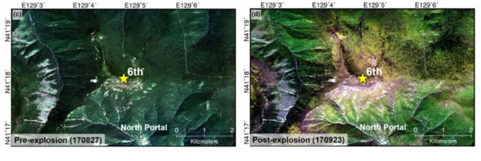
The artificial earthquake from the sixth and final nuclear test was confirmed to be a magnitude 6.3 based on the U.S. Geological Survey, and satellite imagery captured the surrounding environment of Mount Mantap being devastated by the explosion's impact.
▲ Vegetation changes around Mount Mantap immediately after North Korea's 6th nuclear test, captured by Pleiades high-resolution optical satellite (Baek et al., 2020)
In addition, evidence was found showing that the peak of the mountain sank by 0.5 meters and shifted horizontally by 3.5 meters due to the blast impact.
There is also research indicating that fault reactivation could trigger earthquakes of magnitude 6.2 to 6.3 in the area, which could potentially affect the magma chamber of Mount Paektu located about 120 kilometers to the north.
The research findings by the joint team from Pusan National University and China have been published in the international academic journal Science in the United States.
Further details of this research will be reported today (September 18) on SBS 8 News.
※ Please note: This article was translated by AI and may contain errors.
Copyright Ⓒ SBS. All rights reserved. Unauthorized reproduction, redistribution, and use for AI training are prohibited.