SBS News
China Reports 3 Days of Rain Forecast, Warning of Increased Lake Risks
Published : Aug 31, 2026 4:21 PM

▲ Muddy water surges in the Narayani River in Chitwan, about 100 kilometers away from the initial accident site, on August 30 (local time) as cleanup efforts continue following a massive flood in the Himalayan mountainous border region between Nepal and China.
Rain has been forecast once again starting today (the 31st, local time) for three days in the Chinese region bordering Nepal, where a massive loss of life occurred due to a Himalayan landslide.
Concerns are rising over the potential additional overflow of barrier lakes (lakes formed when rivers are blocked by landslides or other events).
An official from the China Meteorological Administration stated on this day, "Rain is expected for three days in Gyirong County, Xigaze City, in the Xizang (Tibet) Autonomous Region," adding, "The amount of rain will be light, with cumulative precipitation expected to be around 10 to 35 millimeters."
The official went on to say that road surfaces may be slippery in areas ranging from Gyirong County to the Gyirong Port due to the rain, and urged rescue vehicles to drive safely.
The official also pointed out, "Continuous rainfall could raise the water levels of rivers and lakes, and further increase the risk of barrier lakes to a certain extent," adding, "We need to continue paying close attention to the impact of the rain on rescue operations and traffic."
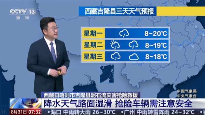
▲ Chinese meteorological authorities forecast three days of rain, warning of increased lake risks
CCTV reported the previous day, citing China's Ministry of Natural Resources, that authorities found about 60 potential geological hazard danger spots based on video analysis and on-site investigations of the disaster's impact range, with initial assessments indicating that 8 of them are in a high-risk state.
The Ministry of Natural Resources is intensively conducting risk factor investigations around glacier collapse sites, barrier lakes, and river channels.
State-run Xinhua News Agency reported the previous day, citing the Ministry of Water Resources, that new water storage areas were created in the wake of this landslide, pointing out in particular that risk factors still remain on Nepalese territory.
It explained that while the "Puruqucuangbo" barrier lake within Chinese territory and a newly formed barrier lake 2.8 kilometers downstream are draining, risk factors still remain in water storage areas such as 5.6 kilometers upstream of the Puruqucuangbo, which is Nepalese territory.
Previously, rain had been forecast for three days starting on the 27th across most parts of Gyirong County in Xigaze City.
According to announcements from the Chinese side, the disaster occurred when glaciers and rocks collapsed on the 26th at an elevation of about 5,200 meters inside Nepalese territory, forming a debris flow.
The debris flow swept down about 22 kilometers in just 6 to 7 minutes, engulfing even the Chinese Gyirong Port.
According to Nepal's National Disaster Risk Reduction and Management Authority, as of this morning, the death toll in Nepal has risen to at least 903, with 4,247 people missing (including 592 foreigners).
Combined with the 16 deaths and 546 missing persons (including 261 foreigners) in the Xizang (Tibet) Autonomous Region compiled by Chinese authorities as of the afternoon of the 29th, the total death toll from this disaster reaches at least 919, with 4,793 missing.
(Photo: Captured from China Central Television (CCTV), Yonhap News)
※ Please note: This article was translated by AI and may contain errors.
Copyright Ⓒ SBS. All rights reserved. Unauthorized reproduction, redistribution, and use for AI training are prohibited.