SBS News
Typhoon Blocked by High Pressure… Why Are Southern Regions on High Alert? [News File]
Published : Aug 27, 2026 10:16 AM
Did the North Pacific High, Which Brought Heatwaves, Push the Typhoon Toward China?
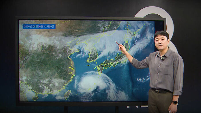
Looking at satellite imagery of South Korea, two massive cloud bands stand out. First, Typhoon Soudel, the 18th typhoon passing near Okinawa, Japan, is visible, alongside linear rain clouds blanketing the area from China to North Korea. These rain clouds stationed over North Korea are secondary monsoon rain clouds. Consequently, the Seoul metropolitan area and Gangwon Province experienced cloudy weather yesterday, blocking out the sunlight. As temperatures dropped compared to the day before, the intensity of the heat subsided. Today, temperatures are expected to reach 31°C (88°F) in Seoul and 30°C (86°F) in Gangwon Province, similar to yesterday. These rain clouds developed along the edge of the North Pacific High positioned over the country. Meanwhile, the southern regions remained under the influence of the North Pacific High, experiencing extreme heat exceeding 35°C (95°F) at the heatwave warning level. However, starting today, rain is expected in the southern regions as well, gradually easing the heatwaves.
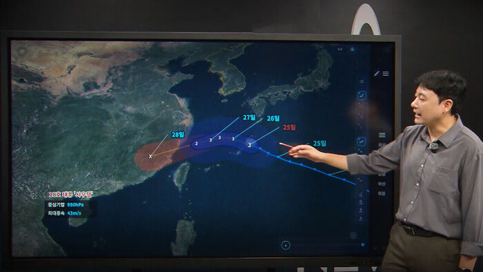
Currently, the 18th typhoon Soudel is passing north of Okinawa, Japan. The intensity of the typhoon is level 3, which falls into the moderate category among the five intensity levels, packing strong winds of 37 meters per second near its center. Although it is currently moving northwest, it is blocked by the North Pacific High and will not be able to reach South Korea. It is expected to gradually change direction and make landfall on the southeastern coast of China around the 28th. Since the distance between the typhoon and Jeju Island will be as far as 580 km at its closest point, South Korea will not be directly affected by the typhoon. While the North Pacific High brought scorching heatwaves, it also acted as a reliable shield blocking the typhoon.
Why Are Southern Regions on High Alert?
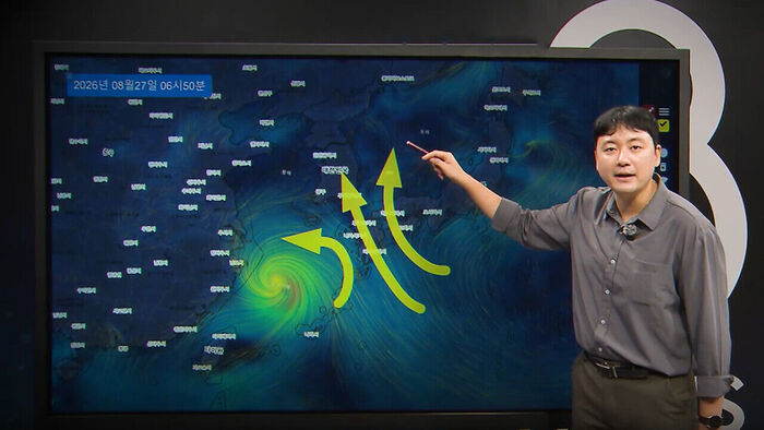
Nevertheless, a counterclockwise flow forms around the typhoon, while the North Pacific High rotates clockwise. Southerly winds develop along the space between the low-pressure typhoon and the high-pressure North Pacific High, pulling moisture from the south toward the southern coast. Consequently, today's expected rainfall is 10 to 60 mm for South Gyeongsang and South Jeolla provinces, and 5 to 30 mm for Jeju Island.
The concern, however, lies in the southern coastal areas of South Gyeongsang Province, such as Geoje and Tongyeong, which suffered damage from previous heavy downpours. The southern coast of South Gyeongsang Province is expected to receive over 80 mm of rain today alone, with fairly heavy downpours reaching 20 mm per hour. While this is not a massive amount under normal circumstances, the ground is already weakened, requiring caution against additional damage. Rain driven by southerly winds is expected to continue into Friday, lowering Busan's temperature gradually from 35°C (95°F) today to 32°C (90°F), and down to 30°C (86°F) on Friday. As rain is forecast nationwide this weekend, the intensity of the heatwave will gradually weaken across the country, though humid daytime heat hovering around 30°C (86°F) will persist.
 Video
Video※ Please note: This article was translated by AI and may contain errors.
Copyright Ⓒ SBS. All rights reserved. Unauthorized reproduction, redistribution, and use for AI training are prohibited.